RideRTC
- 3.7
- Rating
- 1.00M
- Installs
- Free
- Price
 Analysis by App-foxy
When I travel around Southern Nevada, the difficult part is rarely finding a map. The difficult part is turning a planned trip into a practical journey: choosing a stop, checking the route, understanding when to leave, and knowing whether public transit will fit the time I have. RideRTC is built for that specific problem. It is a free travel and local app from RTC of Southern Nevada, aimed at both residents and visitors who use the regional transit network.
I approached it as a decision tool rather than just another route planner. The important question is not whether it can show transit information; most modern map apps can do some of that. The better question is whether RideRTC makes Southern Nevada trips easier enough to justify keeping a dedicated local app on your phone. My answer is generally yes, especially if you use RTC services more than once or twice. For occasional visitors, the choice is more balanced.
The app has been available since September 5, 2016, and its current version is 7.9.6. It supports devices running Android 8.0 or later, carries an Everyone age rating, and has passed the one-million-install mark. Its average score is 3.7 from around 1.8 thousand ratings, alongside more than six hundred written reviews. Those figures suggest a useful but not universally loved tool, which matches my experience: its value depends heavily on how closely your trip matches its local focus.
You May Also Like

 Blood Strike: 2.5 Anniversary
Blood Strike’s Loadouts Turn Every Drop Into a Tactical Gamble
A close look at Blood Strike’s custom loadouts: how fast access to signature weapons reshapes its battle royale rhythm, rewards preparation, and narrows the gap between fights.

 Pandora - Music & Podcasts
Pandora’s Music Is Easy to Start, but Harder to Recover
Pandora’s strength is its low-effort path from a seed to a station. Its weak spot is how much confidence it asks you to place in connection, setup, and quiet recovery.

 8 Ball Pool
 Is Built on Rivalries, Rematches, and Routine
A close look at the rivalries, rematches, shared routines, and unanswered safety questions that turn a quick pool match into a persistent mobile community.

 Samsung Music
’s Quiet Strength Is Playing What You Already Own
Its reach comes less from spectacle than from dependable access to a personal library. That simplicity is both the app’s strongest retention engine and its ceiling.

 AccuWeather: Weather Radar
AccuWeather Review: A Quick, Clear Forecast for Everyday Decisions
For everyday plans, the best forecast is the one you can understand quickly. AccuWeather makes rain timing, radar, and local conditions easy to act on, with a few trade-offs.

 Hill Climb Racing
Why Hill Climb Racing Still Turns Crashes Into One More Run
A tiny car, a bumpy hill and one more upgrade: Hill Climb Racing keeps resurfacing because its simple chaos makes every near-miss feel personal.
More From Our News Desk



How I Decide Whether RideRTC Is Worth Using
My first decision criterion is location. RideRTC makes the most sense when Southern Nevada public transportation is the center of the journey. A general navigation app may be more convenient for a mixed trip involving walking, driving, cycling, and several transit agencies, but RideRTC has a clearer purpose. If I am trying to understand an RTC journey, I would rather begin with an app dedicated to that network than sort through unrelated travel modes.
The second criterion is the kind of planning I need. There is a difference between asking, “How do I get from here to there?” and asking, “Which transit option should I take, where should I board, and how do I keep the trip manageable if I am unfamiliar with the area?” A local transit app earns its place when it reduces that uncertainty. It is particularly useful before leaving a hotel, apartment, workplace, or event area, when a few minutes of preparation can prevent a long walk in the wrong direction.
I also consider how often I travel. A visitor making one simple journey may prefer the map already installed on the phone. A resident, student, hospitality worker, or frequent visitor has more to gain from a dedicated tool because the same local questions come up repeatedly. Once an app becomes part of a routine, the small benefit of having transit information grouped in one place becomes more valuable than the effort of opening a general-purpose alternative.
Finally, I look at the cost of mistakes. Missing a connection, walking to the wrong stop, or discovering too late that a route does not fit a reservation can be much more frustrating than spending a few minutes comparing options. RideRTC is strongest when I use it before the journey, not only after I am already lost. That is an important distinction: it works best as a preparation companion rather than a magic solution for every unexpected change.
A practical scenario: planning a day without a car
Imagine I am staying in Southern Nevada and want to spend the day moving between several destinations without relying on a private vehicle. I would start by checking the first leg in RideRTC, noting the suggested boarding point and the amount of walking involved. Then I would examine the return journey before leaving, because the route that works in the morning may not be equally convenient later in the day.
That second check is one of the most useful habits with a transit app. People often plan only the outward trip and assume the way back will be obvious. In an unfamiliar area, the return stop may be across a busy road, farther from the destination, or served by a different route. RideRTC gives me a place to think through both directions instead of treating the journey as a single arrow on a map.
I would also leave room for uncertainty. A route planner can recommend a sensible path, but it cannot remove the need to identify the actual stop, allow walking time, and watch for changes once I am outside. My practical advice is to take a screenshot or note the key details before starting if I expect weak connectivity or a busy day. I do not depend on any transit app as my only source of orientation.
What makes the local focus useful
The local focus changes how I read the information. In a broad mapping app, transit is usually one option among many, and the screen may prioritize driving directions or walking routes. RideRTC keeps the attention on Southern Nevada transit. That makes it easier for me to evaluate a public-transport journey on its own terms instead of constantly comparing it with a car route I may not want to take.
This is also helpful for people who are not confident transit users. A newcomer may understand a map but still feel unsure about how a local bus trip works in practice. By concentrating on the regional system, the app provides a more relevant starting point than a generic map that treats every city in the same way. I still need to use common sense, but the dedicated context reduces the mental clutter.
For regular riders, the benefit is less dramatic but more dependable. I can use the app to check a familiar trip when something changes in my schedule, or to compare a known route with another option. That makes it useful even when I already understand the network. It is not only for tourists who have never seen a Southern Nevada stop.
Where the experience can feel less convenient
The 3.7 average tells me not to expect perfection, and I think that is a fair warning. A dedicated transit app can feel less flexible than a general map when the journey includes a long walk, a ride from another provider, or a last-minute change of plan. The more a trip moves outside the RTC-centered question, the less obvious the advantage becomes.
There is also a learning cost. Any local transit app asks me to become familiar with its way of presenting routes, stops, and journey choices. A person who already uses a favorite map app may not immediately feel that RideRTC is simpler. The first few trips can require patience, especially if I am comparing several possible departure times or trying to understand which stop is most convenient rather than merely closest.
Another limitation is behavioral rather than technical: the app cannot compensate for poor planning. If I open it only after arriving at an unfamiliar stop, I may still have to make decisions under pressure. I get better results when I use it to prepare, verify the route shortly before departure, and keep a backup plan for walking or another ride. That workflow matters more than simply installing the app.
Choosing Between RideRTC and Other Travel Tools
When I compare RideRTC with a general map, I focus on what I need to decide before setting out: whether the trip is mainly an RTC journey or part of a broader, mixed-mode plan. That distinction helps me avoid juggling tools unnecessarily while still keeping a wider map handy when the route extends beyond transit. I’ll also consider how repeated use changes the value of learning a dedicated local app.
When a general map app is the better choice
I would choose a general map app first when my trip combines several transportation categories. For example, if I need to compare driving, walking, cycling, and public transit in one view, a broad navigation tool may present the decision more naturally. It can also be preferable when the destination is outside the RTC-centered area or when the journey depends on services from multiple networks.
General maps are often familiar, and familiarity has real value. If everyone in a group already knows how to share a location, save a destination, or switch between travel modes in one app, adding RideRTC may create another step. For a visitor making one straightforward trip, that convenience may outweigh the benefits of a dedicated local tool.
There is a trade-off, though. A general map can make public transportation look like just another line among many choices. When I specifically want to understand an RTC journey, that broad approach may be less focused. I may spend more time filtering out options that do not match my plans. RideRTC is the better starting point when transit is not merely one possibility but the reason I am planning the trip.
When a dedicated local tool is the stronger fit
I recommend RideRTC more confidently to people who live in Southern Nevada, work there, or visit often. Repeated use changes the calculation. Instead of opening a general map for every question, I have a focused place to check transit plans. That is especially valuable when I am building a routine around public transportation rather than using it as an occasional backup.
It is also a sensible choice for visitors who want to avoid renting a car or depending entirely on ride-hailing. The app does not need to replace every other tool on the phone. I can use RideRTC for the transit portion, a regular map for the surrounding walking, and my own notes for reservations and meeting times. Thinking of it as one component of a travel setup produces a better experience than demanding that it handle every navigation task.
For families and groups, I would test the route before committing the whole day to it. Public transit can be a good fit, but the amount of walking, the number of changes, and the patience of the group all matter. RideRTC helps me investigate those factors; it does not decide whether a particular itinerary is comfortable for children, luggage, mobility needs, or a tight appointment.
Three habits that make the app more useful
Plan the return before starting the outing. This avoids the common mistake of knowing how to reach a destination but not how to leave it conveniently. I check both directions and pay attention to the walking portion at each end.
Use the app as a route comparison tool, not just a single-answer machine. If I have flexibility, I look at more than one possible journey and compare simplicity against speed. A route with fewer decisions can be better than one that appears faster but is harder to follow.
Prepare a low-connectivity fallback. I record the essential stop and route details before heading out, particularly when I expect a crowded venue or inconsistent signal. This does not replace checking current information, but it prevents the phone from becoming the only thing I know about the trip.
These habits reveal a useful trade-off. The app can reduce uncertainty, but only if I give it enough attention before departure. People who want a single tap that handles every detail automatically may find that disappointing. People willing to spend a few minutes checking the complete journey usually get more from it.
Understanding the cost of switching
Because RideRTC is free, the financial cost of trying it is low. The real cost is attention: installing another app, learning its layout, and deciding when to use it instead of a familiar map. For a one-time visitor, that setup may not be worthwhile. For a frequent rider, the same small investment can pay off through faster planning and less repeated searching.
I would not delete a general map app just because I installed RideRTC. That would create an unnecessary either-or choice. The strongest arrangement is often to keep both: use RideRTC when the trip is primarily about Southern Nevada transit, and use the general map when the journey crosses transportation categories or requires broader location context.
There is no subscription decision to make, and the Everyone rating makes it broadly suitable for households. Still, suitability is not the same as convenience for every person. Someone who rarely uses public transportation, prefers driving everywhere, or travels mainly outside Southern Nevada has little reason to make this a regular part of their routine.
Who should use it and who should skip it
I think RideRTC is a strong match for local residents who regularly plan around public transportation, visitors trying to reduce car dependence, and anyone who wants a Southern Nevada-focused alternative to a general navigation app. It is also useful for cautious planners who like to check the complete route before leaving rather than improvising at the first stop.
I would skip it, or at least treat it as optional, if my trips are mostly outside the region, if I need one app to compare every possible travel mode, or if I already have a reliable workflow in a general map and rarely use RTC services. In those cases, the dedicated focus may feel like extra friction rather than an advantage.
People with very tight schedules should use it as part of a wider plan, not as a guarantee. I would verify the route close to departure, allow extra time for walking and transfers, and keep the destination address available. That advice is not a criticism unique to RideRTC; it is simply the responsible way to use any transit planner when missing an appointment matters.
My recommendation after using it
My recommendation is clear but specific: install RideRTC if Southern Nevada public transit is an important part of your life or trip. The app’s local concentration is its main strength, and the fact that it is free makes experimentation easy. I find it most valuable before leaving, when I can compare the whole journey and prepare for the less obvious parts such as the return trip and walking between the stop and destination.
I would not present it as a universal replacement for Google Maps, Apple Maps, or another broad navigation service. Those tools may be better when the route mixes driving, walking, cycling, and several transit systems. RideRTC earns its place when I want a focused transit companion for Southern Nevada, not when I want a complete travel operating system.
In the end, the app succeeds because it answers a local question directly: how can I make a Southern Nevada transit journey more understandable before I start it? Its limitations appear when I expect it to solve unrelated navigation problems or remove every uncertainty from a real-world trip. For the right rider, that is a worthwhile distinction. If public transportation is central to your plans, RideRTC is worth keeping ready on your phone.
FAQs for RideRTC
01What is RideRTC and what can I use it for?
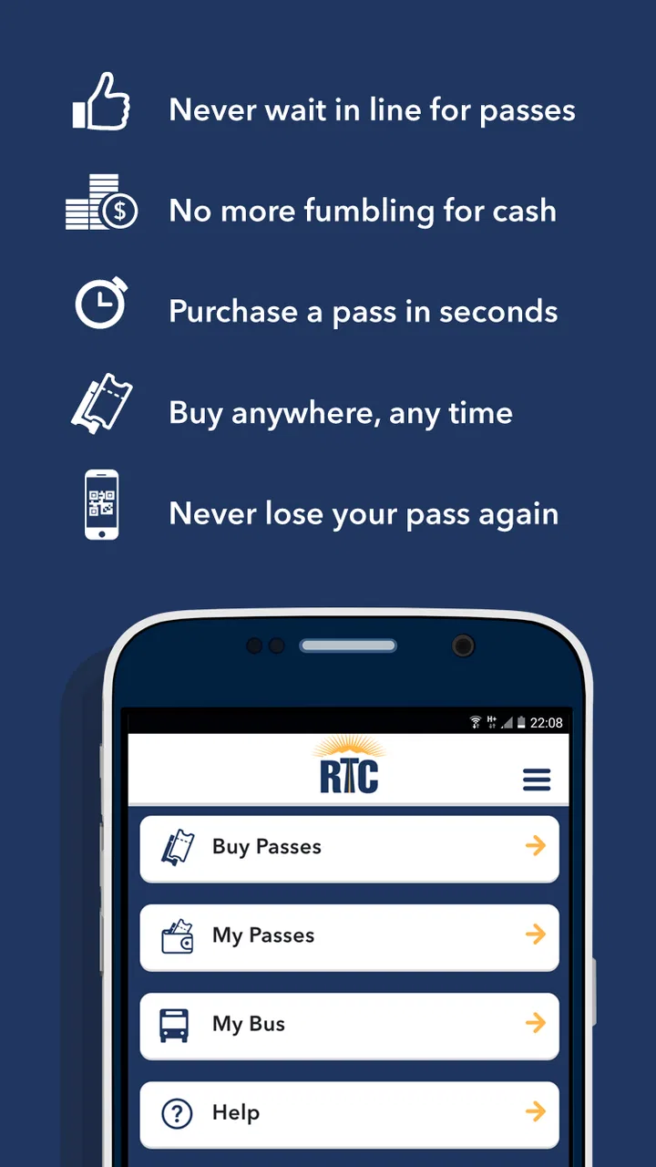
RideRTC is the official mobile app for planning and managing public transportation journeys in the Las Vegas area. It can help you find routes, check schedules, view nearby stops, and receive service information. Depending on the available features and local transit services, the app may also support trip planning and fare-related functions, making it useful for both regular commuters and visitors.
02Does RideRTC provide real-time bus information?
RideRTC is designed to provide transit information such as routes, stops, schedules, and, where available, real-time vehicle updates. The accuracy of arrival predictions can depend on GPS data, network coverage, traffic, and information supplied by the transportation agency. For that reason, users should treat estimated arrival times as guidance and allow extra time when traveling to an important appointment.
03Can I buy or manage transit passes through RideRTC?
RideRTC may include digital fare and pass-management options for supported RTC services, but availability can vary by location, ticket type, and current agency policies. Before relying on the app for payment, check whether your preferred pass is supported and whether the service accepts mobile tickets on your route. Keep your phone charged and follow any activation or validation instructions shown in the app.
04Does RideRTC require an internet connection or location access?
An internet connection is generally needed to load updated schedules, retrieve route information, receive service alerts, and display real-time arrival data. Location access can make it easier to find nearby stops and plan a journey from your current position, although some basic information may still be accessible manually. If you travel with limited data, download or review important trip details before leaving.
05Is RideRTC free to download, and which devices support it?
RideRTC is generally available as a free download for compatible Android and iOS devices, although using public transportation through the app still requires paying the applicable fare. Device compatibility, operating-system requirements, and feature availability can change with updates. Before installing, review the app-store listing, permissions, privacy details, and recent user feedback to confirm that it works properly on your phone.
Pros
- Real-time bus and paratransit tracking helps reduce waiting uncertainty.
- Mobile ticketing avoids handling cash when boarding eligible RTC services.
- Route planning combines schedules
- stops
- and nearby transit information.
- Service alerts can highlight delays
- detours
- and stop changes.
- Useful for checking RTC routes while traveling around the Las Vegas area.
Cons
- Coverage is mainly limited to the Las Vegas Valley and RTC services.
- GPS accuracy may vary in busy areas
- indoors
- or with weak connectivity.
- Some schedules and arrival times can be delayed or temporarily outdated.
- The interface may feel less intuitive for first-time public transit users.
- Ticket availability and supported payment options can vary by service.

RideRTC
Gallery